Storm Update: Atmospheric River triggers life-threatening flooding; Rain advisory issued for all LA County Beaches; Road closures
By The Malibu Times · Wed Feb 12 2025
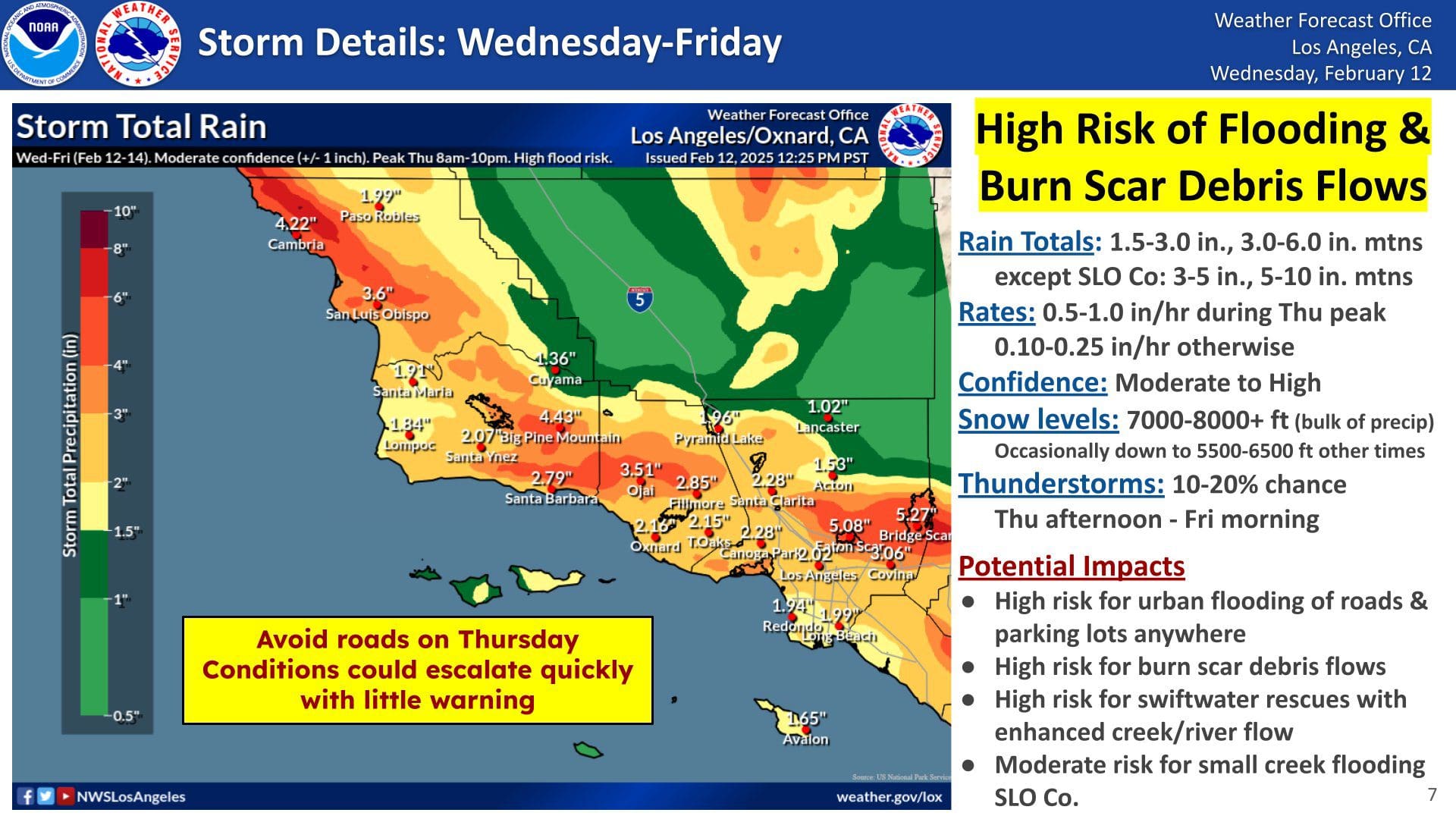
A atmospheric river is barreling into Southern California tonight, bringing 1.5 to 6 inches of rain and posing significant risks of flash flooding and mudslides, particularly in areas affected by the Eaton and Palisades Fires.
Storm Intensification and Forecast
According to the National Weather Service (NWS), the latest satellite imagery shows a rapidly intensifying storm system developing into a strong and potent weather event. A visible baroclinic leaf feature suggests the storm's evolution is progressing at an accelerated rate, increasing concerns over extreme weather impacts across the region.
Evacuation Warnings for Fire Burn Areas
The Los Angeles Fire Department has issued evacuation warnings for residents near recent burn areas. The affected locations include:
- Palisades Fire Area: Getty Villa area, Highlands near the burned areas, Bienveneda area near Temescal Canyon Park, Reseda Blvd/Marinette Road near Will Rogers State Park, and Mandeville Canyon above Tanners Road.
Evacuation Warnings Issued - Dangerous Storm Conditions
The following Malibu zones are now under evacuation warning due to the upcoming storm: MAL-C111-B, MAL-C111-A, MAL-C112-A, MAL-C112-B, MAL-C112-C, RMB-U030-A
Residents should prepare to evacuate now due to the significant risk of flash flooding, debris flows and mudslides. These hazards pose a serious threat to life and property.
Neighborhoods include:
- Carbon Canyon
- Carbon Beach East
- La Costa Beach, La Costa (hillside)
- Las Flores Creek
- Las Flores Mesa
- Eastern Malibu
- Big Rock
- Las Tunas Beach
- Topanga Beach Road
- Carbon Beach Terrace
- Carbon Beach
- Rambla Pacifico
- Carbon Beach West/Malibu Beach
- Sweetwater Canyon
- Sweetwater Mesa
- Serra Retreat
- Malibu Creek
- Cross Creek
- Malibu Colony
- Civic Center
- Malibu Knolls
- Malibu Road
- Malibu Country Estates
- Puerco Canyon
If you choose to evacuate now, head northbound on PCH toward Oxnard or leave via Kanan Dume Road. Gather only essential items such as medications, important documents and pets.
DO NOT attempt to drive through floodwaters – roads may become impassable.
Road closures:
- PCH is closed from Chautauqua Blvd in Los Angeles to Carbon Beach Terrace in Malibu.
- Malibu Canyon Road is closing at February 13 at 1 a.m. between Piuma Road and Adamson Flats
These warnings are expected to remain in effect until at least 2 p.m. Friday, depending on the storm’s progression.
Ocean Water Quality Rain Advisory
The Los Angeles County Department of Public Health has issued a Rain Advisory for all Los Angeles County beaches due to potential contamination from storm runoff. Beachgoers are advised to avoid all water contact, especially near storm drains, creeks, and rivers, where bacteria levels are expected to be elevated.
The advisory will remain in effect until at least 11:00 a.m. on Monday, Feb. 17, but may be extended based on additional rainfall.
Additionally, an Ocean Water Advisory remains in place from Las Flores State Beach to Santa Monica State Beachdue to fire-related debris contamination. While beachgoers may use the sand, they are urged to stay away from fire debris and ocean water during any posted advisories.
For 24-hour updates on beach conditions, residents can call the County’s beach closure hotline at 1-800-525-5662 or visit PublicHealth.LACounty.gov/Beach/.
Stay Safe and Informed
Residents in high-risk areas should prepare for possible evacuations, avoid unnecessary travel, and stay informed through local authorities. Emergency services urge all Southern California residents to exercise extreme caution as the storm moves through the region.
Stay informed:
Sign up for alerts: MalibuCity.org/DisasterNotification
Tune in for emergency updates: 99.1 FM KBUU, KNX 1070 AM / 97.1 FM
Safety Reminder: DO NOT attempt to drive through floodwaters—roads may become impassable.
Evacuation Shelter:
Westwood Recreation Center
1350 South Sepulveda Blvd., Los Angeles