Beachfront resident says Our Malibu Beaches misleads the public
The polarizing coastal access app Our Malibu Beaches is being asked to correct errors that a local homeowner says misleads the public. The app, launched in 2013, guides users to areas of sand possibly otherwise unknown to the general public. The free app has been hailed by coastal evangelists as an innovative tool to opening beach access for all. Others, including many Malibu beachfront homeowners, criticize the app and raise many potential concerns.
One such concern is the privacy of homeowners who say Our Malibu Beaches facilitates and arguably encourages trespassing on their private property. Others point to environmental degradation due to an influx of visitors who may not adhere to proper beach etiquette, such as littering or disturbing wildlife. Some cite the disruption of the tranquility and exclusivity homeowners came to expect with their oceanfront homes located far from beaches designed for public use with restrooms, trash receptacles, and lifeguards.
One example is the 2021 opening of access to La Costa Beach. When residents tried to upgrade a fence at 21704 Pacific Coast Highway, the Mountains Recreation and Conservation Authority (MRCA), which has jurisdiction of the area, had the fence permanently removed. However, since the fence’s removal three years ago, the MRCA has not provided any amenities for the visiting public, including restrooms or even one trash can. This has led to a sanitation nightmare for La Costa Beach residents who have documented piles of trash, soiled diapers, beer bottles, and more left by visitors. Some beachgoers have even lit fires, urinated, defecated, used drugs on the beach, or camped out under resident homes. There have been charges against the MRCA of not providing adequate assignment of rangers to patrol the area.
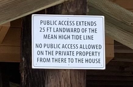
Now, Latigo Beach homeowner Dennis Seider, who this year settled with the California Coastal Commission over the right to post “Private Property” signage at his home, is asking Our Malibu Beaches to correct what he calls misinformation about where the public has the right to access in front of his property.
The issue stems in part from the inscrutable Mean High Tide Line definition, which has pitted beach homeowners against coastal access advocates at least since the enactment of the California Coastal Act in 1976. The Our Malibu Beaches app currently informs the public that, with respect to the Seiders’ home, they “can use dry sand for 25 feet from the High Tide Line to up to five feet from the house.” In asking the app to correct the information Seider says, “HTL [truth is from the Mean High Tide Line, an average of all high tides], up to 5 ft from the house [truth–public can use the first twenty-five feet above the Mean High Tide but that still leaves over 45 feet of private sand between the public easement and the house].” He continues: “Your invitation to the public based on these mistakes has been re-published” in other newspapers.
Seider also wrote to the app, “CCC staff, invited by the judge to settle the case with us, concluded beach front property owners were allowed to post permitted signs dividing public and private areas of the sand by reference to the MHTL. Thus, wet sand that you have invited the public to use is not necessarily public and not likely to be public around high tide, because wet sand is most often the result of wave uprush and is usually above the MHTL. Please correct your frequent reference to wet sand as public—-it is only public if within an easement or seaward of the MHTL.”
Seider claims he had the property surveyed to be sure where the public and private beach was divided and provided the app’s owners with a copy.
Two years ago, one of the app’s owners, Jenny Price, emailed Seider and wrote that they try to make “the app as accurate as we possibly can.” Price’s email also says: “the app says ‘up to’ 5 ft—so the public must respect a 5-foot buffer zone when the high tide line on any given day is less than 30 feet from your house.
“Also, the MHTL (as we explain in the app) is, as you say, an average high tide—for the last 18.6 years. However, no one can possibly know where that is on any given day, so the accepted on-the-ground boundary is the last high tide line, i.e.you can walk on the wet sand. The HTL will be above the MHTL on some days, and below it on others.
“And finally, the MHTL is a vertical, rather than a horizontal, measurement—which simply specifies the vertical height of the tide, rather than where the tide has actually hit the sand, over the last 18.6 years. As the beach erodes, the MHTL, just like the HTL, will move closer to the beach houses—as has happened historically on Latigo and other beaches.”
As Price earlier claimed to make “the app as accurate as we possibly can,” in a July 31 email she deflects accountability to the CCC, which does not operate the app, writing: “we rely on the Coastal Commission for our information on signage and easements.”
The Malibu Times reached out to Price for comment on Seider’s latest request that, consistent with the signs he is permitted to post after his CCC settlement, the app respect his request to inform the public of its right to access not within five feet of his home, as implied by the app description, but only 25 feet landward of the MHTL. TMT is waiting for a response.