The fire season begins with worries over record drought; fire chief urges homeowners to “have an evacuation plan now.” This is the first in a series of stories on Malibu wildfires.
By Vicky Shere / Special to the Malibu Times
Although Malibu residents have always worried about wildfires, record drought has stoked anxiety about the fire season that has descended upon Southern California early this year.
“Fire season now seems to be May through January rather than September and October,” said Rick Wallace, a 32-year resident, noting the January fire on Malibu Road and the May infernos in Griffith Park and Santa Catalina Island. “It’s a whole different feeling of threat, caution and alertness.”
Recently, the National Oceanic & Atmospheric Administration predicted the driest year on record for Southern California, with downtown Los Angeles receiving just 3.21 inches of rain through April 30.
Anything less than 1.20 inches of rain from now through June 30 will mean the driest rainy season since record keeping began in 1877, the agency said.
“We are leaning toward record-breaking drought, with most stations in Ventura and Los Angeles Counties receiving 25 percent of normal rainfall,” said Eric Boldt, a meteorologist with the NOAA’s National Weather Service in Oxnard.
Citing persistent high pressure systems that cause storms to travel over land, where they lose moisture, rather than over the ocean, Boldt also predicts a summer of “above normal” temperatures and a “dryer than normal” winter in 2008.
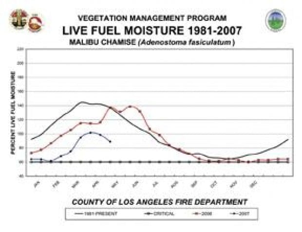
These ominous predictions raise a red flag for Los Angeles County fire officials, whose survey of brush found May live fuel moisture levels near the critical 60 percent level.
Fuels, humidity, temperature and wind all factor into the perfect firestorm causing a major wildfire.
Large amounts of Malibu’s dry, native chaparral brush-one of the most combustible types of brush in existence -provide massive quantities of flammable material.
“This season is completely different than what I’ve seen in 33 years,” said Chief Reginald Lee, who heads the Los Angeles County Fire Department region that includes Malibu. “This is the first time that all fuels in the county are dead at the same level. You can already smell the vapor.”
January frost and scant rainfall have increased dead vegetation, contributing to an early fire season, said Kevin Johnson, assistant Fire Chief of the Forestry Division of the LACFD.
Malibu’s extraordinary fire hazard-a large fire at least once a decade-is shaped, in large part, “by the uncanny alignment of its coastal canyons with the annual fire winds from the north: the notorious Santa Anas, which blow primarily between Labor Day and Thanksgiving, just before the first rains,” writes Mike Davis in his 1996 LA Weekly article chronicling Malibu fires.
“Born from high-pressure areas over the Great Basin, Santa Anas become hot and dry as they descend into Southern California,” Davis continues. “The San Fernando Valley acts as a giant bellows, sometimes fanning the winds to hurricane velocity as they roar seaward through the narrow canyons and rugged defiles of the Santa Monicas. Add a spark to the thick vegetation (frequently over 40 tons per acre in the Malibu area) and uncontrollable wildfire will result.”
This heavy “fuel load,” the amount of vegetation per acre, means the fire will last longer and spread more quickly, Lee said.
As they blow, Santa Ana winds evaporate whatever moisture is left, relative humidity can drop to critical levels and flying embers spark new flames, making a fire almost impossible to contain, Lee added.
So what can you do to eliminate loss of life and property?
In addition to complying with the Fire Department’s brush clearance requirements-inspections of developed property began in May-Lee urges everyone to prepare an evacuation plan “now.”
“We have to get through traffic just like everyone else,” Lee said, noting January’s Malibu Road fire, which spread from Bluffs Park in minutes.
“Everyone should have an idea of what personal items they should take with them,” Lee said. “They should know that now.”
Residents should also plan where family members should regroup after evacuating and which person outside Malibu family and friends can contact for information, Lee said.
Councilmember Ken Kearsley, who was instrumental in hiring Malibu’s Emergency Services Coordinator, agrees with the urgency of an evacuation plan.
“I’ve seen eight fires since 1961 and evacuated three times,” he said. “Until you go through it, you never understand the trauma the fire brings. You can’t be prepared enough.”
Notable Malibu Wildfires
October 1929 Malibu Colony, 10 homes burned
1930 Decker Canyon
1935-1938 Between 1935 and 1938, 400 homes destroyed
December 1956 “La Costa/Hume Fire,” 1,940 acres burned, one person killed, 100 homes destroyed
December 1958 Malibu and Zuma canyons, 18,000 acres burned, eight firefighters injured, 100 homes destroyed
September 1970 “Malibu Canyon/Wright Fire,” 27,925 acres burned, 10 lives lost, 103 homes destroyed
October 1978 Kanan Corridor, Zuma Canyon, Malibu Park, 25,000 acres burned, 230 homes, 254 structures affected
October 1982 “Dayton Fire,” originating Northeast of Canoga Park, through Trancas Canyon to the coast, 42,000 acres burned, 85 homes destroyed
October 1985 “Piuma Fire,” Decker Canyon, 5,160 acres burned
November 1993 “Old Topanga Fire,” at the time “the largest deployment of firefighters in the history of California…[and] the largest mobilization of emergency resources within a one- two-day period in the history of the United States,” 3 civilian deaths, 565 firefighters injured, 16,516 acres burned, 385 homes and 103 structures destroyed.
January 2003 Trancas Canyon, 2,200 acres burned, three homes damaged
January 2007 Malibu Bluffs State Park, Malibu Road, 20 acres burned, 5 homes destroyed, 6 others damaged
Sources: LACFD, California Coastal Commission, Mike Davis, LA Weekly, Nov. 15-21, 1996, The Malibu Times Archives, Malibucomplete.com
