Malibu sounds alarm over fragile stretch of Pacific Coast Highway following fire damage
By Barbara Burke · Wed Jul 29 2026
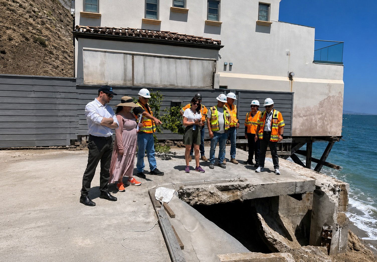
City officials, engineers and coastal property owners warn of increased vulnerability ahead of the winter storm season
As traffic careened within just a few feet along the Pacific Coast Highway, The Malibu Times took a tour of beach lots along Las Flores Beach on July 25 with a group of concerned owners of burned-out coastal lots in East Malibu.
Seasoned journalists have seen a lot of concerning things, what with covering fires, mudslides, bluff collapses, and horrific fatalities in accidents and landslides. However, this reporter was very taken aback and concerned when she observed several areas in the coastal burn zone where the highway is perilously close to failing. Journalists can write about such things, but building and safety officials can take action. Yolanda Bundy, who spoke with The Malibu Times on July 27, is leading such efforts.
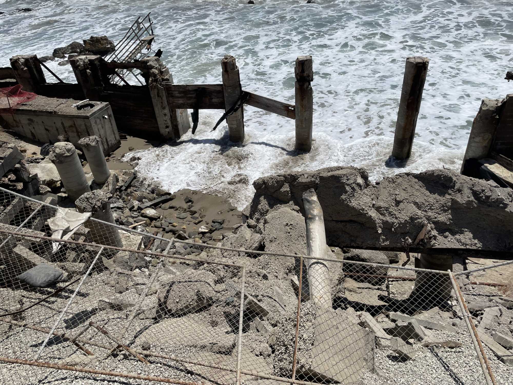
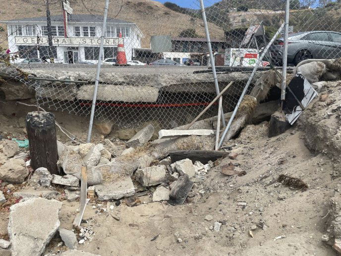
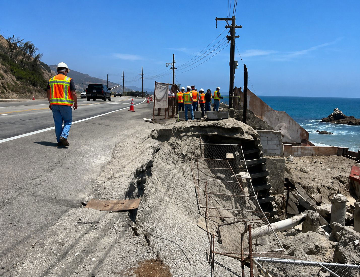
The precarious and perilous areas of concern along PCH
During a tour of the area, I was joined by Malibu native Carl Randall, whose family has owned a home on Las Flores Beach since 1957. Randall recalled evacuating his mother on her 90th birthday — the same day the Palisades Fire broke out — before showing the extensive damage left behind.
Along the tour, Sam Marshall, founding partner of NYMBL Architecture, whose firm has been retained to help rebuild one of the destroyed beach homes, explained that the damage extends far beyond the loss of the houses themselves.
"A Metro bus, a loaded dump truck and an open sinkhole share the same 12 feet of roadbed near Las Flores Beach," Marshall said. "Every house destroyed on the seaward side was also, functionally, a retaining wall. The fire did not just take homes; it removed private structures that were quietly holding the state highway's shoulder in place."
Marshall said that after the fire, debris removal crews cleared the lots, but in doing so also removed much of the highway's lateral support.
"Waves hitting an intact bulkhead result in erosion; waves hitting a cracked septic tank result in contamination," he said. "Now, septic tanks that spent 40 years buried beneath homes are sitting upside down in the surf."
Marshall warned that the coming rainy season could determine the future of the roadway.
"The first winter storm will not test the edge of the highway," he said. "It will decide its outcome."
Further discussing the concerns about the highway, Marshall stated, “The busiest road in Malibu is also its most fragile, and the balance holding its ocean edge together is more delicate than anyone would believe. Where coastal homes existed, nothing on the ocean side of the highway’s white line was designed by the State of California — it accumulated, one permit at a time, over 50 years. A highway is supposed to be the durable thing in a landscape; on this stretch it is the most fragile one, resting on a delicate assembly of private improvements that no longer exist.”
Erosion is doing to PCH what the fire did to the homes
“Asphalt is still right up until it isn’t — it does not sag as a warning, it drops,” Marshall noted. “We are now asking a fragile edge of a highway to carry 40,000 pound loads across a delicate margin of fill along the highway that no engineer ever prepared for. Erosion is doing to this Pacific Coast Highway infrastructure what the fire did to the homes, only slower and out of sight. Undermining of the roadway does not announce itself, it works from below until the surface gives way under a wheel load.”
Gazing across the highway toward the landslide bluffs, Marshall and Randall expressed concerns about the possible impactful harming effects of forthcoming rain predicted by meteorologists to be heavy due to El Nino.
“Rainfall that once ran through a drainage system now runs straight into the shoulder and erodes the highway out into the ocean. The first winter storm will not test the edge so much as decide the ability of it to survive,” Marshall predicted. “As we move toward fire season, PCH is one of the few evacuation routes out of Malibu and is currently the most compromised piece of infrastructure in it. Rebuilding the seaward lots is not a private matter — it is how the highway gets its edge back. You cannot pave your way out of a support problem; it is a fragile road holding a delicate balance, and the only thing currently maintaining that balance is the weather being kind. With a strong El Nino winter approaching, it is only a matter of time before the balance disappears.”
Yolanda Bundy and her team doing all they can — Caltrans must step up
Marshall and Randall as well as traffic safety advocate Meril May emphasized that Yolanda Bundy and her team are doing all they can.
“Readers need to understand that there is no conflation of responsibility on this issue — the city staff, directed by Yolanda, are very dedicated, focused and doing a phenomenal job of issuing permits within the framework in which they must operate,” Marshall opined. “Everyone in our community should be very proud we have such great people.”
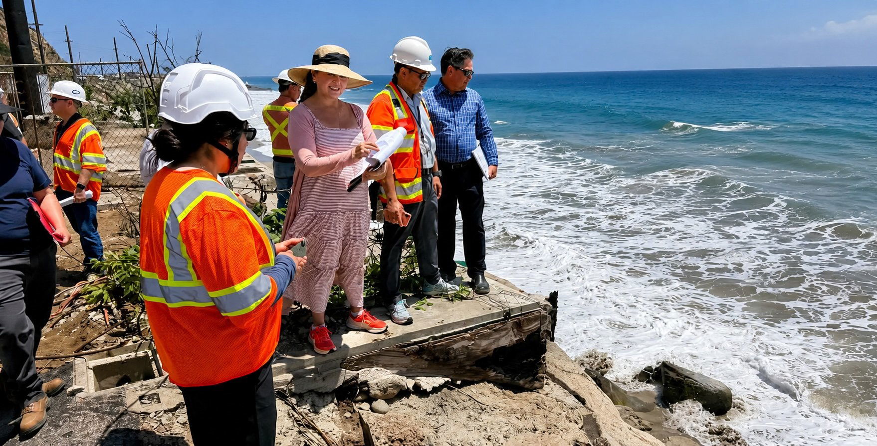
The City of Malibu has red-tagged 16 Malibu Coastal properties
On July 27, The Malibu Times interviewed Yolanda Bundy, community development director for the city, and she is taking immediate action to address the issues. Bundy explained that on July 26, she and a team of engineers and geotechnical experts toured the areas where PCH is failing as well as other areas where the highway is in risk of failing, and the group also toured areas where drainage pipes have failed and where septic tanks remain on coastal lots. In assessing the dangers, the team also took drone footage. The Malibu Times has requested the drone footage, and when it is available, the newspaper will post on social media.
“I have red-tagged 16 properties where it is too unsafe for anyone to be on the properties,” Bundy informed. “My team and I are meeting further with Caltrans and with the governor’s office today to ensure that the state is fully aware of the dangers we are facing.”
Bundy noted that the city issued a notice late on July 27, followed by a social media posting on July 28, informing Malibuites that the city is coordinating with Caltrans to address the coastal erosion along PCH in the Palisades Burn area and that Bundy and her team and Caltrans representatives met with the governor’s office as well. Bundy anticipates touring the various areas where the highway is in precarious conditions with representatives of Los Angeles County Waterworks District No. 29, as well as representatives from Southern California Edison and SoCal Gas to view the site and collaborate on how to best address the issues. She noted that because the telecommunications companies that have their equipment in the area have the equipment on poles above the PCH’s areas of concern, so they are not impacted, at least in the foreseeable future.
Next steps to address the PCH fragility issues
“Our first focus will be to implement temporary repairs. Caltrans is installing K-rails this week on the properties of the gravest concern," Bundy said. “We are keeping a close eye on the areas of concern this and next week, and my team and I continue to assess the drone footage and the properties — I am concerned about this because Hurricane Genevieve is progressing, the areas that are in danger could experience coastal surge.”
Bundy also noted that she and her team would be meeting with owners of the coastal properties that lie within the area of concern that are located in the 20000 block of Pacific Coast Highway. She strongly pointed out in a very reassuring manner, “The fact that the 16 homes are red-tagged is because we want to help the homeowners affected — no one should panic because of the red-tagging. The city is doing so to assist the homeowners in the area. This does not have any implications such as any agency pursuing eminent domain or other options.”
Further, she anticipates future meetings with the governor’s office, Caltrans, SCE, District 29, and other agencies and companies involved in solving the problem.
Longtime locals note that there is great cause for concern if El Nino hits
The Malibu Times spoke with John Mazza, a longtime Malibuite who lived in Paradise Cove when the huge 1983 storm pummeled the Malibu coastline. Locals online are expressing substantial concerns that if El Nino is as strong as most meteorologists predict, the coastal properties damaged in the Palisades Fire are in potential peril
“The 1983 damage was enormous and we actually had three storms in a row in that year,” Mazza shared. “I sat on the cliffs and watched the first thrust of that storm hit the Paradise Cove pier in its center and break it. It would be hard to exaggerate how big the waves were that were landing on that pier. All the pilings on that pier were cabled, and parts of the pilings were all over the beach.”
Mazza added, “A home on Latigo washed out to sea and that had been owned by Rhoda Rindge Adamson and her husband Merritt Adamson. There was significant damage to the Big Rock Beach Cafe as well, a local restaurant that ultimately became Moonshadows.”
When one goes on local social media, he can view an original photograph from the collection of Sara Rindge-Knadler, daughter of Ronald L. Rindge and a great-granddaughter of May Knight Ridge. Rindge-Knadler’s photograph, which was digitally restored by Cary O’Neal (Mr. Malibu©), shows the beautiful Rindge beach house moments before it washed out to sea and another black and white image posted by Rindge-Knadler shows the moment the home was taken by the storm. Mazza also recounted another home being destroyed in the storm a little north of Tuna Beach in the large 1983 storm.
If Mazza is anything, he is a pondering thinker and is not one inclined to overstate. Somberly, he noted, “If the storms we get with El Nino are huge, we could lose other homes in addition to there being possible damage to the burned out coastal properties.”
One expert’s guess regarding how much it will cost to build structural retaining walls along PCH
Catching up with Carl Randall on July 28, he stated, “There are two red-tagged homes on Las Flores Beach — one is close to a permit to rebuild and has Pacific Coast Highway drainage issues and the other one hasn’t started rebuilding and has ZERO seawall left and a partial block wall holding up PCH.” Elaborating, he added, “One more tagged property I see has no sea wall and no retaining wall.”
Grant Sawyer of Pacific Building Group is estimating the additional cost for each fire-rebuild lot of approximately $500,000 for the structural retaining walls along Pacific Coast Highway, according to Marshall, who explained how that estimate was calculated.
“The estimate from Pacific Building Group is an extrapolation from the costs of building foundations,” Marshall explained. “For example, the Randall property at Las Flores Beach has seven 42-inch-diameter piles that are required to run along the PCH frontage, with a concrete retaining wall spanning between them. Some of that capacity supports the house above, but the size and number of piles are driven primarily by one demand: resisting the lateral load of the highway itself.”
Further clarifying, Marshall stated, “The owner is paying to hold up PCH. Those costs do not stop at the permanent structure, because temporary shoring of the highway during construction is its own line item. Between Topanga and Las Flores through Big Rock, these vertical retaining walls range from roughly 10 to 25 feet tall.”
The Malibu Times will keep readers informed when the newspaper acquires the drone footage and Bundy promises this journalist can further interview her about how the action plans to address the PCH dangers are being addressed.