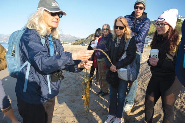
A group of locals interested in documenting sea level rise with photographs gathered at Westward Beach last Saturday to learn the ropes. The California King Tides Project—a partnership of the California Coastal Commission, state and federal agencies and nonprofit organizations since 2010—is an annual winter project where citizen scientists volunteer to take photos of the highest high tides of the year, known as King Tides.
Countries all over the world are now documenting King Tides in order to get a glimpse of how shorelines will be impacted by sea level rise and climate change in the near future. The extreme tides give scientists an opportunity to study what happens to streets, beaches and wetlands when ocean levels rise another one to two feet.
Phyllis Grifman, associate director, Sea Grant Program at USC, told The Malibu Times, “We’re hoping to rebuild our cadre of picture-takers and observers in Malibu. We were on hiatus here for a while, but now we’re back.”
“We also want to raise awareness about how the beach is changing and to receive input from people with eyes on the coast,” added Linda Chilton, education program manager of the Sea Grant Program at USC. “The extreme high tides have an impact on coastal structures and access.”
For those familiar with tide charts, last Saturday’s King Tide was pretty extreme compared to normal: a high tide of 6.67’ at 8:52 a.m. and a low tide of -1.47’ at 4:13 p.m. following Friday night’s full moon.
King Tide photos taken by volunteers are compiled in an interactive online map presenting a geographic view of the images. The volunteers who attended last Saturday learned how to submit their King Tide photos to the project, whether using a smart phone or a traditional camera, and were encouraged to “pick a beach that matters to you” to document.
“Some of the most powerful images are taken in areas that are subject to flooding and erosion, and places where high water levels can be gauged against familiar landmarks such as cliffs, rocks, roads, buildings, bridge supports, sea walls, staircases and piers,” the instructions read.
The images that volunteers send in are used by state and local officials and climate change researchers to validate sea level rise models and assess local flood vulnerabilities. The images are also accessible to the public.
“King Tide” isn’t a scientific term; it describes a high tide event that occurs several times a year in conjunction with full moon and new moon cycles.
Malibu Living Shoreline Project
The Bay Foundation described its Malibu Living Shoreline Project, which aims to restore three acres of sandy beach and dune habitat at Zuma Beach and Westward Beach (agencies call it “Point Dume Beach”) in partnership with the City of Malibu, LA County Department of Beaches & Harbors and California State Coastal Conservancy:
“We’re evaluating the potential of restored dunes to grow, keep pace with sea level rise and protect structures from coastal flooding,” explained Karina Johnston, science director at nonprofit The Bay Foundation. “Our intention is to replace the dune system to provide protection without affecting beach activities.”
Scientists plan to experiment with various types of native dune vegetation, like Beach Bur, to see which types help the dunes stay in place best during sea level rise and storms, and even help dunes grow larger by trapping windblown sand. They plan to pull out and replace all of the ice plants in the test areas, because ice plants are non-native; they don’t collect sand and turn soil acidic.
“It’s a very innovative project,” Johnston added.
Shoreline ecology
Chilton’s King Tides talk went over distinguishing features of high tide marks and other factors.
Seaweed that’s left on the beach at high tide is called beach wrack. The wrack line shows how high the tide came; and the plants in that wrack indicate what’s growing in the ocean offshore, as well as serving as a habitat in itself, which is important to biodiversity, Chilton detailed. Fake sand berms the county’s beach managers create with bulldozers in order to protect structures affect the organisms that live in the sand, as well as shore birds. Their frequent practice of raking and removing the wrack also does ecological harm, Chilton said.
The next King Tides are coming Feb. 8-9, 2020. Anyone interested in becoming a volunteer citizen scientist to take and submit photos of the shore during the King Tides may contact Linda Chilton at 213.740.1965 or lchilton@usc.edu for instructions.
Editor’s note: A quote in an earlier version of this story was removed at the request of The Bay Foundation.


