Weather Update: Winter storm slams Malibu area; Topanga Canyon Boulevard closed, evacuations remain in effect
By The Malibu Times · Mon Feb 16 2026
A powerful winter storm continues to impact Malibu, Topanga Canyon and much of Los Angeles County, triggering road closures, evacuation warnings and significant travel disruptions across the region.
Topanga Canyon Boulevard Closed
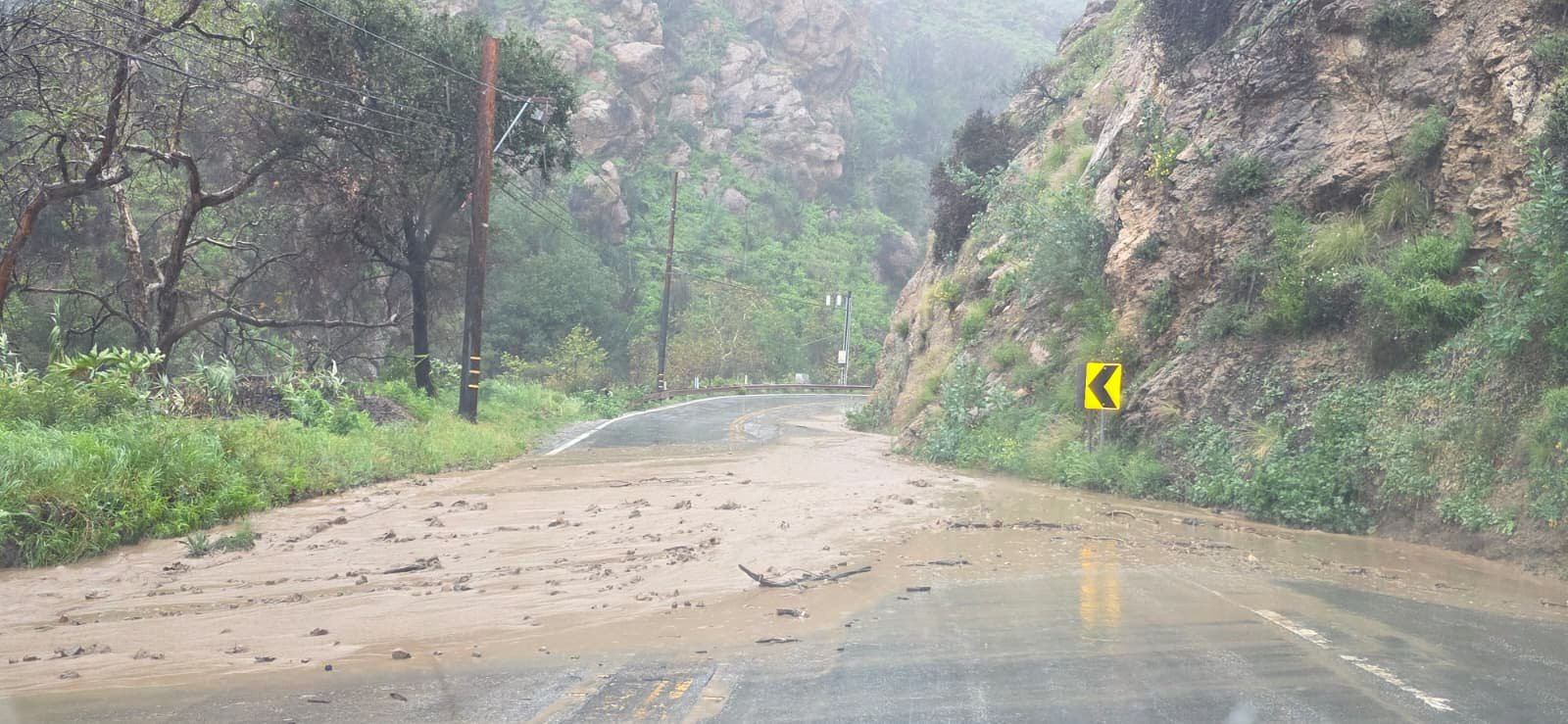
Topanga Canyon Boulevard (State Route 27) remains closed in both directions from Pacific Coast Highway to Grand View Drive until further notice due to heavy storms and hazardous conditions. Multiple locations within the closure area have experienced mud and debris slides.
Maintenance and GeoTech teams are on scene assessing slope stability and clearing debris. Caltrans crews have been preparing for the storm by relocating equipment, installing K-rail barriers, placing sandbags and stabilizing retaining walls along SR-27 and nearby sections of Pacific Coast Highway. The highway will reopen only once it is deemed safe.
Motorists should expect the closure to remain in place at least through the Tuesday morning commute, with possible extensions depending on storm impacts.

Current Conditions in Malibu
As of Feb. 16, around mid-to-late afternoon PST (approximately 4:39 p.m. PST), Malibu is experiencing ongoing rain from the storm system affecting Southern California.
Current conditions include:
- Light to moderate rain, with occasional heavier bursts
- Cloudy and windy skies
- Temperatures ranging between 55 and 57 degrees Fahrenheit
- A high probability of continued precipitation in the short term
Earlier thunderstorms brought periods of heavier rainfall, and while the current rate appears lighter, additional downpours remain possible.
Recent rainfall totals:
- Approximately 0.17 inches fell about 30 minutes prior to late afternoon reporting (around 4 p.m. PST).
- About 0.16 inches accumulated over the past 24 hours, though totals vary by location depending on local gauges and storm intensity.
- Hourly rainfall rates during peak activity may have reached 0.5 to 1 inch in short bursts, increasing the risk of localized flooding and debris flows.
Soils in Topanga and surrounding burn scar areas are already saturated from recent storms, heightening concerns as additional rain moves through the region.
Heavy Rain and Flood Risk
The National Weather Service forecasts the most intense period of rainfall Monday, particularly between 6 a.m. and 6 p.m., with showers continuing through much of the week.
Projected storm totals include:
- 2 to 4 inches across coastal and lowland areas
- 4 to 8 inches in mountain and foothill communities, especially within burn scar zones
The Weather Prediction Center has issued a slight risk of excessive rainfall for the central and southern California coast through Tuesday morning, warning that heavy rain could create localized flash flooding in urban areas, roads, small streams and wildfire burn scars.
Thunderstorms remain possible, bringing gusty winds, reduced visibility and isolated hazards such as brief tornadoes or waterspouts.
Evacuation Warnings in Burn Areas
Evacuation warnings remain in effect for neighborhoods impacted by last year’s devastating wildfires, including areas scarred by the Palisades Fire and related burn zones such as Sunset and Hurst. The warnings were issued following a flood watch covering a wide swath of Los Angeles County.
Mayor Karen Bass said she has directed emergency crews and city departments to be prepared to respond to mudslides, debris flows and flooding.
Residents in burn scar areas are urged to remain alert, gather essential items and monitor official emergency alerts through Tuesday.
LAX Ground Stop and Travel Impacts
The Los Angeles International Airport (LAX) issued a ground stop for departing flights Monday as heavy rain moved across the region. Travelers are advised to check directly with their airline for updated departure information.
Drivers throughout Los Angeles County should anticipate standing water, downed trees and potential traffic signal outages. Under California law, motorists must come to a complete stop at any malfunctioning signal.
Dangerous Marine Conditions
The National Weather Service has issued a gale warning through 2 a.m. Tuesday for inner coastal waters from Point Mugu to San Mateo Point, including Santa Catalina and Anacapa islands. Southwest winds of 20 to 30 knots, gusting to 35 knots, and combined seas of 6 to 9 feet are expected.
A special marine warning was also issued after radar detected severe thunderstorms capable of producing waterspouts, with wind gusts exceeding 50 knots. Impacted areas include Dana Point, Newport Harbor, Alamitos Bay and the Port of Los Angeles. Mariners are strongly urged to remain in port or seek safe harbor.
Beachgoers should be aware of heavy surf, rip currents, beach erosion and storm debris in the water.
Utility and Emergency Response
Pacific Gas & Electric said it is using artificial intelligence and machine-learning enhanced weather models to determine where to stage crews and equipment.
“This weather event will progress in several phases,” said incident commander Paul Bury. “On the coast, we’re expecting heavy rains and winds, whereas the higher elevations are going to see snow. We’re staging crews to make sure they are ready to safely restore power to customers in a timely manner.”
Sandbag Locations
Sandbags are available at:
- All LA County Fire stations (some locations provide sand)
- Camp 13, 1252 Encinal Canyon Road — sand and bags
- Fire Station 70, 3970 Carbon Canyon Road — sand and bags
- Zuma Beach main entrance, 3000 Pacific Coast Highway — sand and bags
- Malibu Library, 23519 Civic Center Way — filled sandbags available through April 15 (staff will load vehicles from 9 a.m. to 4 p.m.)
Residents are reminded not to remove sand from beaches.
Safety Reminders
Officials urge residents to:
- Stay off the roads if possible
- Prepare for mudslides, debris flows and standing water
- Be ready for potential power outages
- Watch for emergency crews and work vehicles
- Check on vulnerable neighbors
- Never approach downed power lines — call 911
Authorities continue to emphasize vigilance as the storm system moves through the region, with conditions expected to evolve over the next several days.